Recently, there was a rather amusing news regarding the chim (profound) names of the new housing estates at Sengkang and Punggol.
Some joke that the job of a taxi driver will get tougher next time with the latest Build-To-Order (BTO) flats given fanciful names like Matilda Portico(柱廊), Ancilla(女随从), Nautilus(鹦鹉螺), Periwinkle(长春花), Edgedale Green, Waterway Sunbeam, Spectra(光谱) and The Coris (红喉盔鱼).
Most public housing estates in Singapore are easily recognisable by their block numbers or street names, such as Ang Mo Kio Street 43 or Bedok South Avenue 3, but the “branding” of HDB housing estates is not something new. Kim Keat Court was the first such “branding” in 1995, although its name may sound ordinary by today’s standard.
The Colloquial Names
Beside the official names, there used to have an alternate type of naming of streets, places or landmarks that proved to be popular among locals. Call them variant, common or colloquial names, these vividly descriptive names were simple, easy to remember and largely reflect the history of certain places. Ask any older generation of Singaporeans, and they are likely to be able to pinpoint you the exact locations of “mang kah kar“, “orh kio tau” or “pek sua pu“.
The early Chinese immigrants, mostly from South China, could not really comprehend the English names of the streets named by the British, such as Phillip Street and Waterloo Street, so they took matters into their own hands and named the roads in their familiar Hokkien, Teochew and Cantonese dialects. Many were named after the notable landmarks in the vicinities where the streets ran through, such as temples, markets, trading houses or even a rich or famous man’s residence.
Others were named after bridges, cemeteries, hills or just simply numbers. Today, many locals still fondly call the seven parallel roads near City Hall “first (main) road” to “seventh road”. Waterloo Street, known as “si beh lor” (四马路, fourth road) is arguably the most famous of all, due to the popularity of the Kwan Im Thong Hood Cho Temple.
City Hall vicinity
The vicinity around present-day City Hall, bounded by Crawford Street, Jalan Besar, Fort Canning and the Singapore River, was generally known as “sio po” (小坡, little downtown) in the past, where a large number of its streets had colourful colloquial names.

In the sixties, the Ellenborough Market (1845-1968) and Clyde Terrace Market (1872-1983) were the two largest public markets in Singapore, situated at opposite sides of the Singapore River. Standing at the junction of Beach Road and Rochor Road, the Clyde Terrace Market was nicknamed “ti ba sat” (铁巴刹, iron market) due to its iron framework. Rochor Road, therefore, became better known as “market lane” in Hokkien, even after the market was demolished in the eighties.
“dok lee kio” (独立桥, independence bridge) actually refers to the Merdeka Bridge, opened in 1956 together with Nicoll Highway, linking the city to Kallang, Geylang and Mountbatten over the Kallang Basin. Over the years, the variant name became the reference for Nicoll Highway instead.

The vicinity around Istana Kampong Glam was a historic district once belonged to the Malay royalty of Singapore. Sultan Gate, the road leading the former palace, was well-known for its iron-smiths; some of them still plying their trades today. Hence, Sultan Gate was given a range of variant names such as “pah ti koi” (打铁街, iron-smith street), “ong hoo kau” (王府口, mouth [front] of palace) and “tua che kar” (大井脚, foot of big well), referring to an old well at the middle of the road.

Famous for its flea market and charcoal-cooked laksa, Sungei Road is better known as “gek sng kio” (结霜桥, frosted bridge). The name was derived from the establishment of the Singapore Ice Works, the major ice supplier in Singapore, at the junction of Sungei Road and Pitt Street in the 1930s. The factory, however, was shut down in the early eighties with its site taken over by HDB.
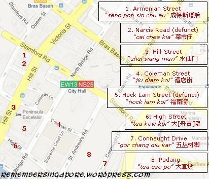 In the 19th century, Tan Seng Poh 陈成保 (1830-1879), a wealthy Teochew opium farm owner as well as a municipal commissioner and Justice of Peace, built a large mansion at Loke Yew Street near Fort Canning. The house was so prominent that the local Chinese named the adjacent Armenian Street as “seng poh sin chu au” (成保新厝后, at the back of Seng Poh’s new house).
Trading houses and godowns (warehouses at the dockside) used to line up on both sides of the busy Singapore River filled with many old traditional wooden boats called sampans (舢板), tongkangs (舯舡) and twakows (大[舟古]). These provided inspirations to the variant names of the roads beside the waterway. High Street was known as “tua kow koi” (大[舟古]街, twakow street) while Clarke Quay and Boat Quay are called “cha zhun tau” (柴船头, front of wooden boat) and “zhap buay keng” (十八间, eighteen [trading] houses) respectively.
Raffles Place vicinity
The streets in the modern Central Business District (CBD), filled with skyscrapers, office towers and banks, are a far cry from their appearances in the old days. During the 19th and early 20th century, the southern part of the Singapore River, known as “tua po” (大坡, large downtown) was a place mixed with legitimate businesses and illegal activities. Old dingy shophouses lined up along the cramped streets, housing the street hawkers, coolies, Samsui women, secret society members and prostitutes.

One notoriously famous road within the vicinity was China Street. Better known as “giao keng kau” (赌间口, mouth [front] of gambling den), it was then filled with gambling dens and secret societies. One particular Hokkien secret society Ghee Hin Gongsi (义兴公司) was so powerful and influential that the local Chinese also called China Street “ghee hin koi” (义兴街, Ghee Hin street).
Other colloquial names that were named after secret societies were the Upper Nankin Street, Upper Cross Street and Carpenter Street. The former two were coined “seong pek koi” (松柏街, Seong Pek street) and “hoi san koi” (海山街, Hoi San street), named after Siong Pek Kwan (松柏馆), or Siong Pek Gongsi, and Hoi San (海山), two large Hakka secret societies that functioned as the oversea branches of Tiandihui (Heaven and Earth Society) in Qing China. Carpenter Street was known as “ghee hock hang” (义福巷, Ghee Hock lane), where Hokkien triad Ghee Hock Gongsi (义福公司) ruled their territories.
The gambling and unlawful activities were eventually eliminated in the late 1930s by the British government.

“tau hu koi” (豆腐街, tofu street), made famous by the local Chinese drama of the same namesake in 1996, was the colloquial name for Chin Chew and Upper Chin Chew Streets, where there were many beancurd makers and sellers in the late 19th century. The beancurd trade, however, disappeared by the early 20th century. The streets then became known as “orh sa koi” (黑衣街, black shirt street), referring to the red headgear and dark shirts donned by the Samsui women who led a tough life living in the tiny cramped cubicles of the old shophouses.
Affected by the constructi0n of Hong Lim Complex, Upper Chin Chew Street was expunged in the late seventies.

Telok Ayer Market, the trademark orthogonal-shaped market at the junction of Raffles Quay and Cross Street, had a long significant history dating back to 1822. Despite its conservation as a national monument in 1973, it had to be dismantled in the mid-eighties due to the construction of the Mass Rapid Transit (MRT) tunnels at Raffles Place. In 1989, the market’s signature iron-frames were reassembled in a $6.8 million renovation, and was renamed as “Lau Pa Sat” (老巴刹, old market), a name that had been used by the locals for decades.

In the 1860s, land reclamation and the construction of a seawall were carried out at the mouth of the Singapore River. A road named Collyer Quay was completed in 1864, and offices, godowns and trading houses started to emerge at the new street. At Johnston’s Pier, red beacon lights were installed, which later led to the local Chinese’s naming of Collyer Quay as “ang teng beh tau” (红灯码头, red light pier). The famous Change Alley and Arcade also became known as “tor kho hang” (土库巷, godown lane).
Some streets at “tua po” were derived from the Chinese temples situated. One of them is Magazine Road’s Tan Si Chong Su Temple (陈氏宗祠), built in 1876 as an ancestral hall for the Tan clan in Singapore and a temple for Chen Yuan Guang (陈元光), a famous Tang Dynasty general worshipped at Taiwan and Southeast Asia. Over time, the deity’s honorary title “tan seng wang” (陈圣王) became the colloquial name for Magazine Road.
Another example is Phillip Street, commonly known as “lao ya keng” (老爷宫, deity palace). It refers to Yueh Hai Ching Temple (粤海清庙), Singapore’s oldest Taoist temple built in 1826.
Chinatown/Tanjong Pagar vicinity
“gu chia zhui” (牛车水, buffalo cart water) is possibly Singapore’s most well-known colloquial name, so famous that the Chinese name of Singapore’s Chinatown had taken reference to it instead of the usual “Tang Street” (唐人街).
The colloquial name, however, refers to the bullock carts that delivered the fresh water between Ann Siang Hill and Telok Ayer Bay for consumption and cleaning of the streets. “gu chia zhui” is not limited to Kreta Ayer Road only; it refers to the vicinity that generally covers between Mosque Street and Neil Road.

Eu Tong Sen Street, the main road to Chinatown, was nicknamed “nam tin cheng” (南天前, front of Southern Sky), referring to the Great Southern Hotel that once stood at the junction of Eu Tong Sen and Upper Cross Streets. Completed in 1936, it was the tallest skyscraper in Chinatown and was the first Chinese hotel to have a lift. Today, the hotel no longer existed; its conserved building has been converted into a departmental store called Yue Hwa.

Lai Chun Yuen Theatre (1887-1942) was a famous Cantonese opera theatre located at Smith Street before the Second World War. It was so popular that the locals named Smith street as “hee hng koi” (戏院街, theatre street). Its widespread fame also ensured the theatre was taken as the main reference for the nearby Temple Street and Trengganu Street, which were simply called “hee hng au” (戏院后, back of theatre) and “hee hng hang koi” (戏院横街, street adjacent to theatre) respectively.

It once housed many sago flour factories and, later, brothels before the early 20th century, but Sago Lane was more famous for its death houses that lined up the street until their ban in 1961. Its variant name “sei yang koi” (死人巷, lane of the death) vividly described the dreadful scene back then, where many old and sick folks were left to live out the remaining of their days.
By the mid-seventies, part of Sago Lane was expunged for the construction of the Kreta Ayer Complex and HDB flats. Some of the former funeral paraphernalia shops at Sago Lane were moved to the adjacent Banda Street.

Cheng Cheok Street, also known as “gu kar wan” (牛角湾, bull horn bay), was formerly an important crossroad at Tangjong Pagar. Its colloquial name referred to the goods-carrying bullock carts that plied their routes between the Singapore River and the wharves. The road was later expunged in an urban redevelopment project, replaced by Tanjong Pagar Plaza and its flats in the mid-seventies.
Tiong Bahru vicinity
There were many familiar colloquial names around the old estates between Bukit Merah and Tiong Bahru. The terms “ho zhui sua“, “orh kio tau“and “si bai po” easily ring a bell with many Singaporeans.

One of the first Indians to arrive at Singapore in the early 19th century, the sepoys, hired by the British East India Company, were initially accommodated in the barracks near Outram Road. The military site later became known as “si bai po” (四排坡, sepoy plain), a phonetic interpretation of the name Sepoy Lines. After the Singapore General Hospital (SGH) was established at Sepoy Lines in 1882, it became associated with the colloquial name instead.
Some elderly Singaporean Chinese today still harbour subconscious fear of “si bai po“, due to the word “si” which also means dead in the Hokkien and Teochew dialects, even though the colloquial name has nothing to do with death.

One end of Havelock Road, near Beo Crescent, used to be known as “orh kio tau” (乌桥头, head [start] of black bridge). It belonged to one group of past colloquial names that referenced after bridges. Other than Havelock and Sungei Roads, there were “orh kio” (乌桥, black bridge), “pek kio” (白桥, white bridge) and “gao tiao kio” (九条桥, nine bridges), referring to Balestier, Moulmein and Upper Thomson Roads respectively.
Queenstown vicinity
When HDB high-rise flats were built at the early housing districts such as Queenstown, Tanglin Halt, Strathmore, Dawson and Commonwealth, many were confused by their official English names. An easy way to remember the different locations was to nickname the estates according to the height of their flats.

Hence, Tanglin Halt was coined “zhap lau” (十楼, ten storeys). The former iconic Forfar House at Strathmore Avenue was popularly known as “zhap si lau” (十四楼, fourteen storeys), while “zhap lark lau” (十六楼, sixteen storeys) generally referred to the area around Commonwealth Close, Commonwealth Lane and Commonwealth Crescent.

Other “shorter” versions included “gor lau” (五楼, five storeys), “qek lau” (七楼, seven storeys) and “gao lau” (九楼, nine storeys), referring to the SIT (Singapore Improvement Trust) flats at Tiong Bahru, Redhill Close and St Michael’s respectively.
As more HDB flats were built in other parts of Singapore, the conventional naming became impracticable, and probably discontinued due to confusion.
Kallang/Serangoon vicinity
For many years, the iconic blue cylindrical tower and its incinerator chimneys at Kallang was well-known as “huey sia” (火城, fire city), a colloquial name derived from the nearby residents’ phobia that the facilities would explode. Fortunately, the fear of a fire disaster was never realised, as Kallang Gasworks produced an amazing 137 years of continuous supply of gas until its closure in 1998.

“mang kah kar“, the colloquial name of Lavender Street, has been the subject of debate for years. Was it the Hokkien translation of 芒胶脚 (foot [end] of jackfruit) or 蚊咬脚 (mosquitoes bite leg)?
Apparently, there were many jackfruit plantations near the junction of Lavender Street and Serangoon Road in the old days. Jackfruit was called nangka in Malay, but the local Chinese somehow mistranslated it into mangka. Hence, the street was coined “mang kah kar“, meaning the end of a jackfruit plantation. It had nothing to do with mosquitoes although the pesky insects were abundant in the plantations. An interesting trivia of Lavender Street was that its official name “lavender” was originally, and ironically, referring to the foul smells of night soil and fertilisers used for the plantations.
“kim jio kar” (金蕉脚, foot end] of banana) was another colourful colloquial name in the vicinity, but it was unknown whether there were large banana plantations at Petain Road in the past. It is, however, more famous as a red-light district today.

Largely known as “Little India” today, the Serangoon Road had a rather romantic name: “nam seng heu hng pi” (南生花园边, side of Nam Seng garden), which referred to the Whampoa’s Gardens, a Chinese garden beside the grand mansion built by Hoo Ah Kay (1816–1880), one of the wealthiest men in Singapore during his time.
Jalan Besar, on the other hand, was known as “kam gong ka por tai ter long” (甘榜加卜宰猪厂, Kampong Kapor pig slaughterhouse), due to the numerous pig abattoirs, situated between Desker and Rowell Roads, in the old days.
Upper Serangoon vicinity
When the colonial-flavoured estate of Serangoon Gardens was built in the fifties, the eye-catching red roofs of the early batches of houses led to its colloquial naming of “ang sar lee” (红砂厘, red zinc). The name is still commonly mentioned by the older residents today, outlasting its lesser known cousins of “zhap ji cheng” (十二千, twelve thousands) and “zhap si cheng” (十四千, fourteen thousands), both referring to the prices of the houses in the vicinity during the sixties and seventies.
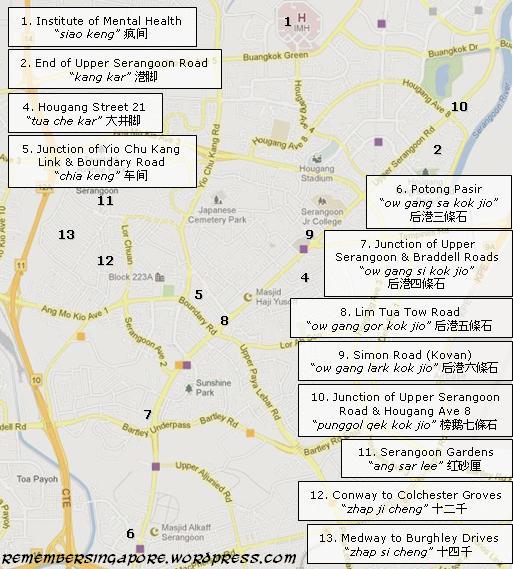
Another local way of naming the places was using the milestone method, in which one milestone was approximately equivalent to 550m. The origin or “point zero” started from the Fullerton Building (previously General Post Office), and the milestones were measured with reference to “point zero” on the old long roads that extended to the rest of Singapore, such as Bukit Timah Road, Jurong Road, Punggol Road and Changi Road.
An example was the Upper Serangoon Road, where there were [ow gang] “si kok jio” ([后港]四條石, Hougang 4th milestone – near the junction of Upper Serangoon Road and Upper Aljunied Road), “gor kok jio” ([后港]五條石, Hougang 5th milestone – Lim Tua Tow Road) and “lark kok jio” ([后港]六條石, Hougang 6th milestone – Simon Road).
Other examples were:
Beauty World – Bukit Timah (Upper Bukit Timah Road) 7th milestone
Bukit Panjang – Bukit Timah (Upper Bukit Timah Road) 10th milestone
Cheng Hwa Village – Bukit Timah (Upper Bukit Timah Road) 11th milestone
Chong Pang (Old) Village – Sembawang (Road) 13½th milestone
Hun Yeang Village – Tampines (Road) 9th milestone
Jalan Ulu Sembawang Village – Sembawang (Road) 2nd milestone
Jurong Village – Jurong (Upper Jurong Road) 7th milestone

Kampong Sungei Tengah – Choa Chu Kang (Road) 13th milestone
Kampong Teban – Tampines (Road) 7th milestone
Princess Elizabeth Estate – Bukit Timah (Upper Bukit Timah Road) 9th milestone
Sixth Avenue – Bukit Timah (Road) 6th milestone
Somapah Village – Changi (Upper Changi Road) 10th milestone
Teck Hock Village – Tampines (Road) 7½th milestone
Thong Hoe Village – Lim Chu Kang (Road) 13th milestone
Tua Pek Kong Kau – Yio Chu Kang (Road) 11th milestone
Tuas Village – Jurong (Upper Jurong Road) 18th milestone
Many of these names were associated with villages, and when these villages were demolished, the names also ceased to exist.
Elsewhere in Singapore
The colloquial names of places elsewhere in Singapore:
Arumugam Road (“gu cai ba“, 韭菜芭, farm of chives)
Bukit Brown (“kopi swa“, 咖啡山, coffee hill)
Chai Chee (“chai chee“, 菜市, vegetable market) – referring to the small markets selling fresh produce from the nearby farmlands.
Changi Village (“changi buay“, 樟宜尾, end of Changi)
Coleman Bridge (“tiao kio tau“, 吊桥头, head [start] of suspension bridge)
Dhoby Ghaut (“kok tai“, 国泰, Cathay) – referring to Cathay Cinema at Handy Road
Elgin Bridge (“ti tiao kio“, 铁条桥, iron bridge)
Java Street (“pah jio koi“, 打石街, mason street)
Kampong Silat (“gu kia swa“, 龟仔山, little tortoise hill)
Kandang Kerbau (KK) Hospital (“tek ka“, 竹脚, foot of bamboo)
Lorong Tai Seng (“dai seng hang“, 大成巷, Tai Seng lane)
Old Holland Road (“kek nang ba“, 客人芭, Hakka farm) – referring to the Hakka villages in the vicinity during the sixties and seventies
Ord Bridge (“tse kio“, 青桥, green bridge)
Rangoon Road (“gia dau hang“, 拿豆巷, aloe lane) – referring to the plantations of aloe in the vicinity in the old days
Seletar (“goon kang“, 军港, military port) – referring to the British Royal Air Force base and Seletar Airport
South Buona Vista Road (“gao zhap gao wan“, 九十九弯, 99 bends) – referring to the numerous bends of the road
Springleaf (“nee soon kang kar“, 义顺港脚, foot of Nee Soon port or “chia zhui kang” 淡水港, fresh water port) – referring to the flavourable deep waterways at Sungei Seletar
Telok Blangah Way (“sit lat mun“, 石叻门, Silat door)
Thomson Garden (“gor ba keng“, 五百间, five hundred houses), referring to the terrace houses in the vicinity

By the eighties, new colloquial naming of places and landmarks almost came to a stop, probably due to the government’s efforts in discouraging dialects and promoting the usage of Mandarin and English.
Some of old names can still be found today though, particularly at the hawker centres or kopitiams where they are used by the food stalls as their signature branding. A few that come to mind are the “giao keng kau you zar kueh” (赌间口油条) at Maxwell Market, “ow gang lark kok jio hokkien mee” (后港六條石福建面) at Simon Road and “mang kah kar char kuay teow” (芒胶脚炒馃条) at Ang Mo Kio Avenue 10.
All maps credited to Google Maps
Published: 28 May 2013
Updated: 06 November 2016


I believe it was Clifford Pier (located beside Collyer Quay) which was known as 红灯码头, not Collyer Quay itself.
Hi there, you are right. Collyer Quay was known as “ang teng lor” (red light road). “ang teng beh tau” was originally referring to Johnston’s Pier, demolished in 1930s.
There was once a huge carpark outside Clifford Pier (today’s OUE tower/bayfront) merging with Collyer Quay. An extremely popular nightspot among food lovers having their suppers at rows of mobile hawker stalls. Over time, when “ang teng beh tau” was mentioned, Collyer Quay came to mind as well. “ang teng lor” instead became less commonly used.
Similar to “dok lee kio” (independence bridge), which referred to Merdeka Bridge but also could mean Nicoll Highway (certain stretch).
(Photo Credit: National Archives of Singapore)
i think most people simply called that area “ang teng”
Tan Kar Kee long kau. Do you know where is that. That’s where I grew up.
Hi, I stayed in Kampong Teban from mid sixties to early eighties, I remembered it was puay-ko jiok (8th mile stone). I also remembered the term “per-zui-po (flying ship’s plain)” frequently used (refering to the built-up slope of the Paya Lebar Airport on the side of Tampines Road), the end of the lengthy lorong halus was known as “sai-long” (shit collection centre?) and the end of lorong baling was known as “jio-long” (rock factory)…
You wrote that Tanglin Halt was known as “chap lau.” Strangely enough this colloquial name was also applied to the Mountbatten–Kg Arang Road housing estate (a small one — originally 14 HDB blocks, one demolished in the 1980s to make way for a car park). My mum used to tell the SBS bus conductor “sup lau” (she’s Cantonese) whenever we were returning from a shopping trip to Katong, and he would invariably nod and punch a 40¢ and 10¢ ticket. I don’t think we knew about the other “chap lau” — would be interesting as SBS 14, which we frequent, ran past Kg Arang and terminated at Bt. Merah (not too far from Tanglin Halt?), but we never got overcharged once.
It is a wonderful collection of the transition from the past to present with great effort. Salute!
May I make some suggestions:
Middle Road is 海南一街
Padang is also known as 海皮(Cantonese)
Merchant Road is 戏馆街
Carpenter Street is 漆木街
China Town Street no. 13 is 水车街
China Town Street no. 15 is 广合源街
Club Street is 大门楼
South Buona Vista Street is 九曲十三弯
Amazing research. Not sure if you a history teacher . 🙂 Thanks for sharing the interesting bis of information.
Had a great time reading this, very well written and researched. Thumbs up!
Fabulous article. Enjoyed it tremendously. Brought back lots of memories.
I grew up along Albert Street, and it was called “Ah Bah Kweh” in Hokkien.. Phonetically equivalent to Albert Street, but with the great hawker stalls at the end of Albert Street at the junction of Selegie Road (where Fatty Weng’s was), I wonder if the Hokkien words actually meant “duck meat”.
Somehow I always feel sad reading these posts… How much things have changed!
I read that some taxi drivers get confused over River Valley and Rivervale (Sengkang)… That’s still not too far apart (in terms of distance), not when you get mixed up between Loyang Way (near Pasir Ris) and Lok Yang Way (at Tuas)!
muahahaha!! True story, i recently directed my boss who supposed to meet a client at Lok Yang Way to Loyang Way.
Do you know where is Ku ah Sua (龟儿山)?
Is it this one?
Kampong Silat (“gu kia swa“, 龟仔山)
Just to help along a little, the word “仔“ in Hokkien is pronounced as “ah” and literally has no meaning in a name except maybe meaning “small”. It is unique in Hokkien dialect to make it easier for the listener. For example, instead of Gu Sua (龟山), we say Gu Ah Sua (龟仔山), but not Gu Kia Sua. Thus, “蚝煎“ is also known as “蚝仔煎” and pronounced as O Ah Jian and not O Kia Jian. “八间仔” is pronounced as Buay Geng Ah. “Kia” , on the other hand, is usually written as ”子“。That said, “山仔顶“ was however better known as Sua Kia Deng instead of Sua Ah Deng.
My Grandma used to live in “四脚亭” Xi Kar Deng, which is in the vicinity of Jalan Membina after urban renewal, not too far from Kim Tian Road, where the old King’s Theatre (璇宫戏院)was situated. I remember “四脚亭” was also known as Dua Long Gau or Dua Long Gang (大漋溝)。
I remember Mom used to go to “铁枝仔内” (Ti Gi Ah Lai) to shop. I believe it is somewhere in Dua Po or Sio Po, have you heard of it and where it was in them days?
Hi! Does anyone have any information on Ku Ah Sua? I am trying to gather more information about this place in the old days. Thanks!
The popular 赌间口油条 at Maxwell Market
(Photo Credit: http://sg.openrice.com/)
Hi, for your SioPo map, No. 8 should be further down Middle Road and closer to 26 and 27, because while Middle Road is long, the stretch that is inhabited more by Hainanese should be closer to Beach Road. Also, other name for Middle Road, “Chuo Dori” which was what Japanese called it, was missed out.
Fantastic post! Thank you for all the hard work that went into compiling this.
Yes. Thank you for the memories. Well done 🙂
These are the memories I have from the narrations of my mum and grandparents. Great to have a pictorial location to the names now. Amazing.
I think the Straits Times article will be invalid after some time, so better archive it here just in case:
http://www.straitstimes.com/breaking-news/singapore/story/matilda-portico-hdb-gets-the-name-game-20130519
A portico is a columned walkway that originated in ancient Greece. Nautilus is a shellfish and the name of Captain Nemo’s submarine in the Jules Verne classic 20,000 Leagues Under The Sea. What about ancilla? It does not exist even in the Oxford Advanced Learner’s Dictionary, but is said to have a Latin origin and apparently means girl servant, or sea snails.
These words, however, have somehow found their way onto the Housing Board’s list of names for public housing estates. Among the latest Build-To-Order (BTO) projects announced in March this year was one in Punggol called Matilda Portico. Compassvale Ancilla in Sengkang Central and the Nautilus in Punggol are the other names the HDB has come up with in recent years. Others include Waterway Sunbeam, Punggol Spectra, The Periwinkle, Edgedale Green and The Coris.
Thanks for the great post – brought back fond memories! Now I know where the various places are – orh kio tau, mang kar kar etc. Just wondering where is si kar teng (四脚亭) ?
Hi, it’s at around Jalan Membina-Tiong Bahru (see Tiong Bahru vicinity). Also sometimes called 四角亭, it referred to an old Hokkien cemetery in this vicinity that existed until 1894.
Most former Chinese cemeteries were named XX亭, such as 泰山亭, 恒山亭, 毓山亭, 碧山亭, etc. (Will do an article on this some day ;))
Thanks. Now I know.
The terrible death house at Sago Lane (sei yang koi) c.1900
How depressing it was to be left dying alone… sigh
(Photo Credit: The Straits Times)
Serangoon North was referred to by my grandmother as Hwi Yoh. There is also a Hwi Yoh CC and Hwi Yoh Sec School. Do you know the meaning of Hwi Yoh and how it came about?
Hi, I used to stay at Serangoon North for about 15 years too.
Maybe I could answer that.
“Hwi-Yoh” is hokkien.
“Hwi” – refers to porcelain, and “Yoh” refers to “窑”, which is kiln in English.
This place must have many porcelain-making kilns in the past!
Correct me if I am wrong.
Rgds.
Oh I see, thank you for sharing the information! 🙂
I would still like to know if they had so many porcelain-making kilns in the past that the name stuck!
The road Jalan Hwi Yoh makes me think of my secondary school days (1964 – 1967). This is a very long (kampong) road leading from YCK Rd to almost somewhere in AMK Town. Near the junction of YCK Rd is a row of semi-detached houses (1-5?). I fondly remember my ex-school mate (Miss L.G.C.) staying at Hse 3. The road now only serves these few houses. 😦
Brings tears welling in my eyes – the nostalgia of the old S’pore I’d once knew & grew up in. Changes might be good but I think S’pore grew up too fast & too rapid. There is a dislocation between the past & the present where there is no bridge except for a website like “Remember Singapore”. The saddest thing for me is that the Singapore I remember fondly lives in my mind, not in the physical presence.
BTW, I’d remember the Simon Road Fried Hokkien Mee well. It was located inside a dingy coffeeshop at the junction of Simon Road & Upper Serangoon Road just before it branches to Tampines Road. There was a night market (pasar malam) there in the vicinity many years ago. Recall trying the fried hokkien mee a few times, it was delicious but not outstanding. Remembered Ponggol Nasi Lemak set up stall @ Hougang Lark Ko near there & there’s always a long queue of hungry diners & takeaways.
I lived at Moulmein Road in the 50’s, it was called “Mee Kwa Keng” and during the 60’s I noticed the address of a Shell Petrol Kiosk along Tampines Road spelled as “Tampenis Road.
No wonder we pronounce it as TamPenis instead of TamPines.
Tommy
I was living at Rochor (Rochore) Road next to 7 Storey Hotel in 1960-1980. Rochor Road was called as ‘路班让 Lo Panjang’ and not ‘Pasar Hang’. Thank
I believed Pasar Hang is the same as Mee Suai Hang which is refer to Beach Lane (Behind Rochore Road). There is a wet market and many make shift stalls in the Beach Lane till mid 70s.
I stayed at ‘Deng Tiam Heng’ (Craig Road, just off Tg Pagar) in the seventies, and remember ‘Duxton Road’ was called ‘Kampong lai’ in Hokkien – translating meaning ‘inside the kampong’.
great memories come flooding back, i used to live at Upper Cross Street (Dua Po Hock Hai).
thank you sir, for the great post.
Ti Ki Ah Lai (inside.within the iron bars – in the Hokkien dialect) refers to the old People’s Park. I also know that Kong Chio Kau (Knock stones Mouth- at the entrance of the stone masons’ yard) refers to the junction of Chin Swee Road and Havelock Road. Chin Swee Road is also called Chiu Long Lye (within the wine factory). Clemenceau Bridge was the Cheh Kio (green Bridge) not Ord Bridge.
Miss the colorful old Singapore,its uniqueness. Only ‘old’ people can appreciate. Now there is nothing unique about Singapore, what you can see in Singapore, you can also see elsewhere. if I’m a foreign tourist to Singapore, I will ask, what’s so special about Singapore?
The special information of this old Singapore is not only for old people like myself, it is a treasure we should be proud of to look back and see what Singapore is like today! Singapore has progress very well and we as Singaporean should be proud of our heritage.
In Paya Lebar Gardens there are several road names in Malay: Jalan Korban (Sacrifice Road), Jalan Mahir (Skillful Road), Jalan Gotong Royong (Co-operative Road), In the same genre is Thrift Drive. Further down is Lim Teck Boo Road, named after the father of Harold Lim, author of the book A Singapore Life.
Circuit Road was known as “Ah junied Chap Lao” meaning Aljunied ten-storeys, refering to those ten-storey blocks. The road used to be called Persiaran Kelliling. ( I remembered the pronounciation but not sure about the spelling.
I lived in one of the 3(?) 10-storeys HDB blocks south of Jalan Merpati (renamed Merpati Rd. later) north of Matter Rd. and Convent in 1960s before I left Singapore in 1970. I remembered these blocks were referred as ““Aljunied Chap Lao”. These blocks disappeared when I returned to Singapore in 1989. Jalan Merpati connects Circuit Road, the HDB blocks here were developed a bit later then those built on Jalan Merpati.
I am glad to have such a ready reference to the old street names of Singapore. Well done!
I note in this article the correct references to the colloquial names of Hainam Street 1 (Seah Street), 2 (Purvis Street, where I used to stay) and 3 (Middle Road). You may like to alert the author of the article “Old, Common Names of Places in Singapore, and their Origins” to make the corrections of the wrong reference to Purvis Street as Hainam Street 1 (p.3) and Seah Street as Street 3 on p.13 (hai nam sai koi).
Would you know what this name of the street called in Cantonese ‘Seven Wood Stree’ (qi mu kie)?
Regards.
Thank you for sharing about Hainam Street 1, 2 and 3. 漆木街(paint wood street) is the current Carpenter Street.
Enjoy our good old Singapore memories.
Missed out 10 mile! Zhap go
I recently spoke to my 90 years old mother and she mentioned 2 places with Hokkien names that I would like to share:
1. Ban Chiu San 万树山(in Hokkien means ten thousand trees hill) this is in the vicinity of Telok Blangah
2. Pon Soh Por 糞掃埔 (in Hokkien means rubbish or garbage place) this should be at the junction of Tiong Bahru Road and Henderson Road probably before the Redhill MRT station
Similarly, there were many Tamil colloquial names for local streets, which were often mixed with Malay words in describing the sceneries and businesses found along the streets.
Albert Street, also known as Thimiri Thidal, or “the place where people thread on fire”. The name derived from the fire walking ceremonies which were held annually at Albert Street in the early 20th century.
Arab Street was also known as Pukedai Sadakku, or “street of the flower sellers”. It was where there were many flower sellers who sold jasmine and marigolds, the sacred flowers of the Hindus. Other than jasmine and marigolds, the vendors also sold other varieties that were sought after by Chinese nonyas and Malay ladies, including bungah meloh, bungah tongking (temple flower), bungah sundal malam (flower of the courtesan of the night) and bungah China or white alamander.
Beach Road, similar to the Chinese colloquial name, was called Kadal Karei Sadakku, or “road by the seaside”. Clyde Terrace was Irumbu Pasar (“iron market”) and Cross Street was Palkedai Sadakku (“street of the milk sellers”).
Dhoby Ghaut, or Vannan Therevu (“street of the dhobies”) was the home of Tamil dhobies. The Esplanade was known as January Thedal (“January Place”) because the New Year land sports were held there. Masak Arak Sadakku (“arrack distillery street”) was the Malay-Tamil name for Havelock Road.
McKenzie Road was called Thanni Alei Sadakku (“water engine street”), due to the pumping station there. Similarly, Thomson Road was known as Tanni Pilei Sadakku (“water pipe street”) because of the reservoir in the vicinity.
https://eresources.nlb.gov.sg/newspapers/Digitised/Article/straitstimes19330709-1.2.77
Aljunied 10楼= circuit road